
 點擊圖片放大
商品名稱:
image master標準版/PRO版
測量軟體 3D掃瞄軟體 3維量測
測量軟體 3D掃瞄軟體 3維量測
詳細介紹:
ImageMaster標準工作流程

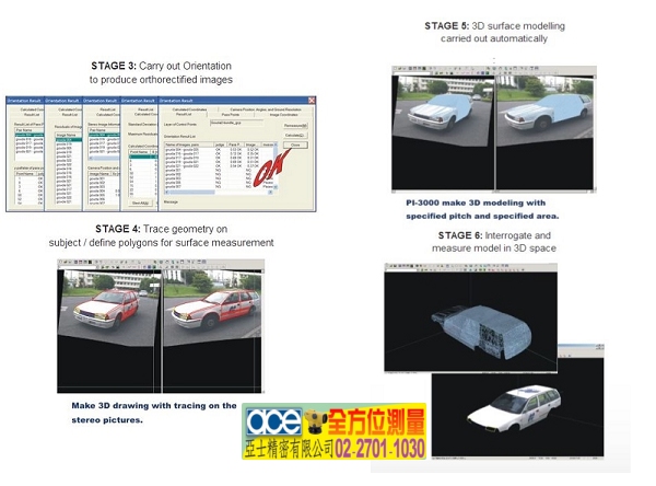
ImageMaster標準工作流程
更多商品

Trimble Business Center
Trimble Business Center 後處理測量軟體 TRIMBLE TBC PC軟體
Micro Survey STAR NET
MicroSurvey STAR*NET V7 is an easy-to-use Windows application that adjusts 2D/3D survey networks using rigorous Least Squares techniques.STAR*NET handles networks containing conventional observations combined with GPS vectors, with up to 10,000 adjustable stations. Differential leveling observations can also be included within a 3D adjustment. Whether a survey consists of a single-loop traverse or a complex network of interconnecting traverses, all observations are adjusted simultaneously to produce a single best-fit solution. STAR*NET can reduce observations to NAD27, NAD83 or UTM with separate grid factors calculated for all distances and t-T corrections calculated for all angles.MicroSurvey STAR*NET V7,Microsurvey 公司全新改版, 操作更具彈性, 可直接安裝在32位元和64位元電腦, 是一套最容易使用的視窗版測量平差應用程式, 使用嚴格的最小平方法(Least Square)技術調整2D/3D 的測量網,多年來廣受全世界測量人員一致肯定與愛用. 簡單易用是它的特點.廣泛的被使用用於變形測量與精密的控制測量的平差計算, 是控制測量平差調整的最佳選擇.STAR*NET 可處理10000個可被調整測站的傳統觀測資料, 水準觀測資料可包含於3D的平差, 不管觀測資料的組成是單導線或導線相互連結的複雜網形,所有的觀測資料都可同時被調整以產生單一最適解, STAR*NET 可化算觀測資料至 NAD27, NAD83 或 UTM 對所有的距離使用分別計算的網格因子和對所有的角度使用計算的三角三邊更正.
MicroSurveyR CAD
MicroSurvey CAD is a Complete Desktop Survey and Design Program Created for Surveyors, Contractors and Engineers.No plug-ins or modules are necessary. Complete Survey Drafting, COGO, DTM, Traversing, Volumes, Contouring, Point Cloud manipulation and Data Collection interfacing are included. MicroSurvey CAD is compatible with field data from all major total stations and data collectors and is fully compatible with AutoCAD. MicroSurvey CAD 是以功能強大的 Intellicad 為核心的工程測量專業CAD設計與繪圖軟體, 是專為測量人員與工程承包商和設計人員所開發的應用軟體, 功能強大簡單易學易用快速解決繁雜的測量計算與繪圖.除了具有完整的CAD的繪圖功能外, 更具有強力的COGO座標幾何計算功能、導線計算與平差、道路線形設計與計算、DTM數值地形模型快速繪製等高線, 自動剖縱橫斷面, 計算土方的挖填數量, Microsurvey CAD以經濟的價格讓您擁有令人難以置信的功能, 是工程測量必備的軟體.
